Our Goals
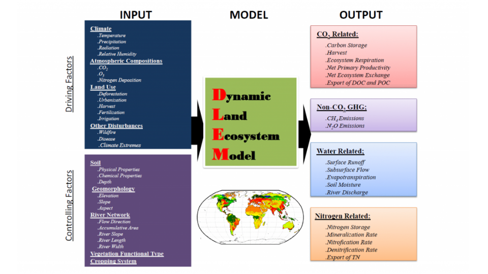
The mission of the Dynamic Land Ecosystem Model (DLEM) is to advance a comprehensive, process-based understanding of how terrestrial ecosystems respond to natural and human-induced drivers across multiple spatial and temporal scales. By integrating carbon, nitrogen, and water cycles with land use, vegetation dynamics, and climate variability, DLEM aims to generate spatially explicit, data-driven simulations that support improved prediction of greenhouse gas emissions, ecosystem productivity, and environmental change. DLEM strives to provide a scientifically robust platform for assessing the impacts of climate change, land management, and policy interventions on ecosystem services and global sustainability. Through collaboration with interdisciplinary research communities, DLEM seeks to enhance our collective capacity to address pressing societal challenges related to food security, climate mitigation, biodiversity conservation, and resilient land stewardship.
Components
The DLEM is a terrestrial ecosystem model that couples major biogeochemical cycles, hydrological cycle, and vegetation dynamics to estimate daily carbon, nitrogen, and water fluxes and pool sizes.
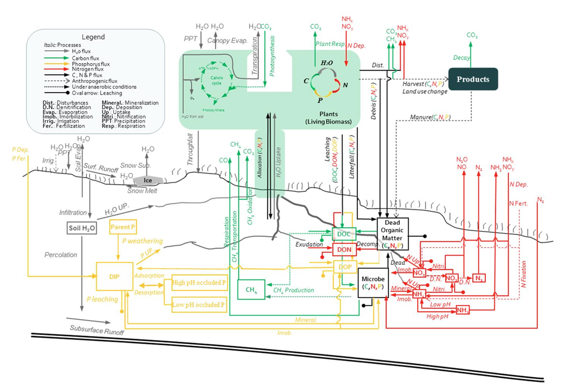

The soil biogeochemistry component simulates N mineralization, nitrification/denitrification, NH₃ volatilization, leaching of soil mineral N, decomposition, and fermentation.
The biophysical component includes the instantaneous exchanges of energy, water and momentum with the atmosphere. It includes aspects of micrometeorology, canopy physiology, soil physics, radiative transfer, hydrology, and surface fluxes of energy, moisture and momentum that influence simulated surface climate.


The land use change and management component simulates the biogeochemistry of managed ecosystems, including agricultural ecosystems, plantation forests, and pastures.
The plant physiology component in DLEM simulates major physiological processes, such as photosynthesis, autotrophic respiration, carbon allocation among root, stem, and leaf, turnover of living biomass, nitrogen uptake and fixation, transpiration, phenology, and more.


The dynamic vegetation component in DLEM simulates two major processes: (1) the biogeographical redistribution of vegetation under changing climate conditions, and (2) plant competition and succession during vegetation recovery after disturbances. Similar to most Dynamic Global Vegetation Models (DGVMs), DLEM uses Plant Functional Types (PFTs) to represent vegetation distributions and their ecological traits.
The agriculture management component in DLEM represents a wide range of human activities that directly regulate terrestrial biogeochemistry. It includes crop planting and harvest cycles, fertilizer and manure applications, irrigation, residue management, tillage practices, and crop rotation strategies. These management actions alter ecosystem carbon, nitrogen, and water fluxes, influencing productivity and greenhouse gas emissions across agricultural landscapes.

To drive DLEM v4.0, long-term spatial datasets at a resolution of 5×5 arc-min were developed, including climate, atmospheric CO₂ concentration, nitrogen deposition, soil properties, land use and land cover change, crop rotation, N fertilizer use rates, manure N application rates, irrigation, tillage intensity, and the earliest and latest crop planting dates.
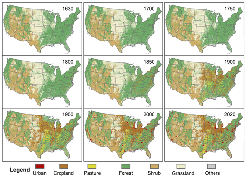
Land use and land cover (LULC) change is an essential component of global change, which has directly transformed ecosystems across most of Earth’s ice-free land area. Human-induced LULC changes—such as cropland expansion, deforestation, and urbanization—have profound impacts on climate change, carbon and nitrogen cycles, and biodiversity. Meanwhile, sustainably managing agricultural and forest lands has been recognized as a critical pathway to achieving climate mitigation targets. Therefore, a better understanding of historical LULC patterns and their spatial–temporal dynamics is crucial for quantifying the effects of LULC change on ecosystems and climate.
The large amount of excessive reactive nitrogen (N) in terrestrial ecosystems has led to multiple environmental issues. In light of the critical impacts of N excess on the human–Earth system, numerous efforts have been conducted to generate distribution maps of N inputs for different sectors with varied temporal coverage and spatial resolution. We employed multiple statistical data, empirical estimates, atmospheric chemistry model outputs, and high-resolution land use products to generate the HaNi dataset. This comprehensive dataset consists of N fertilizer/manure application to cropland, manure application/deposition to pasture, manure deposition to rangeland, and atmospheric N deposition on all agricultural land at a resolution of 5 arcmin for the period from 1860 to 2024.
